Drive west from Brighton along the A27, and the South Downs are always there on your right — the long chalk ridge that runs parallel to the coast, rising and falling. From the dual carriageway they look unremarkable: rounded, green, treeless except for the occasional planted clump. But if you stop driving and start walking, if you get up onto that ridge and look back south to the sea and north across the Weald, and if you know what to look for in the grass and the earthworks, the landscape starts to speak differently.
There are five Iron Age hillforts on this stretch of the Downs that I want to think about together: Cissbury Ring, Wolstonbury Hill, Devil’s Dyke, Chanctonbury Ring, and Mount Caburn. They are not evenly distributed, they are not identical in form or scale, and they are separated by several thousand years of wildly different use. But they share a position — high ground, exposed, visible for miles and seeing for miles — and they share a long history of meaning that started with the people who built the earthworks and has not stopped since.
What a hillfort is (and isn’t)
The term “hillfort” is something archaeologists use while quietly acknowledging its awkwardness. It implies a military function that is, at best, partial. The Iron Age sites on the South Downs are enclosed areas of high ground, defined by one or more circuits of ditches and banks (ramparts). They required extraordinary amounts of labour to construct. Some were densely occupied, with internal roundhouses, storage pits, and evidence of metalworking, grain processing, and craft production. Others show very little evidence of permanent occupation at all.
The working model has shifted over the decades. The older reading — defended hilltop settlements, tribal capitals, refuges in times of warfare — hasn’t disappeared, but it now sits alongside other possibilities. Assembly places, seasonal markets, centres for redistribution of goods, arenas for the display of power. Possibly all of these at different times. Possibly different things at different forts. The South Downs examples cover a range that makes simple generalisations difficult.
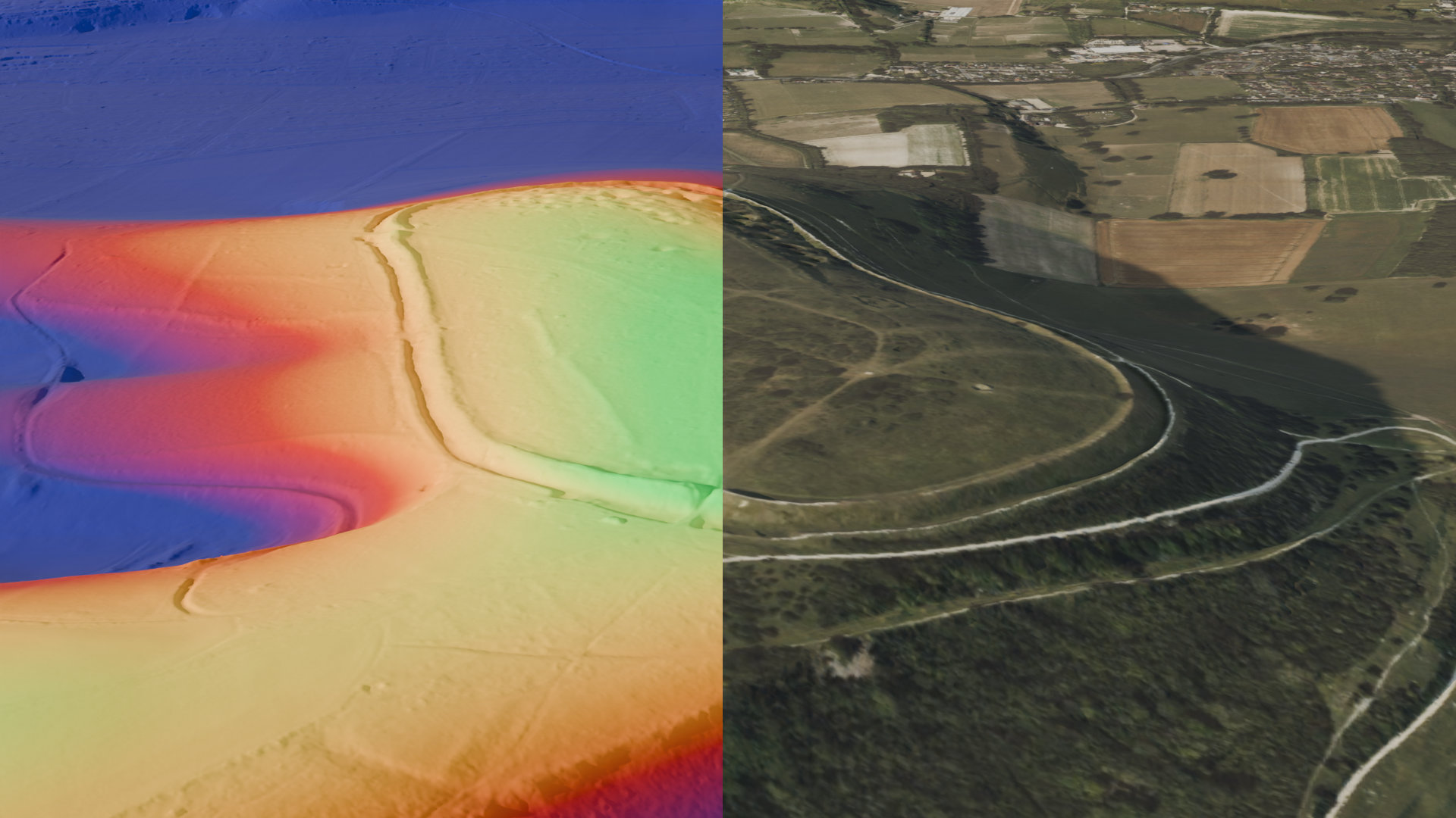
Cissbury Ring
Cissbury is the scale benchmark. At roughly 26 hectares, it is one of the largest hillforts in England — bigger than anything else on the Sussex Downs, enclosing an area that could comfortably contain a small modern village. The main rampart phase dates to around the 3rd or 4th century BC, and the site shows genuine evidence of occupation: Iron Age pottery, storage pits, structural remains.
What makes Cissbury unusual — arguably extraordinary — is what lies beneath the hillforts. The ridge here is riddled with Neolithic flint mines, shafts dug down to the good floorstone flint some ten metres below the surface, dated to roughly 4000–3000 BC. They were discovered in the 19th century and have been excavated at intervals since. Some shafts still dimple the interior of the hillfort as visible depressions in the turf. When the Iron Age community chose this particular hill and dug their rampart ditch, they were digging into ground that had already been worked for two thousand years. Whether they knew what lay beneath in any meaningful sense is unknowable — but the hill had a prior history, and whatever that represented, they built over it.
The view from Cissbury is the clearest argument for why this site was chosen. The coastal plain stretches south to the Channel. Inland, the Weald opens up to the north. On a clear day — and there are clear days up there, even in March — the Isle of Wight is visible to the west. This is not accidentally prominent ground.
Wolstonbury Hill
Wolstonbury is smaller and stranger. The earthworks are a roughly circular enclosure on a detached hill north of the main escarpment, near Clayton. They are genuinely ambiguous: the bank is slight, there is no clear ditch, and some analysts have questioned whether this is even a conventional hillfort at all — perhaps an earlier enclosure, perhaps a different kind of place. There is a round barrow within the enclosure, which suggests the site had significance before the Iron Age earthworks (if that’s what they are).
What Wolstonbury does have is position. It sits isolated from the main ridge, so it reads differently in the landscape — you can see it from several directions, and from its summit you look across to the two windmills at Clayton (Jack and Jill, postmedieval, but the landscape axis is older than the mills). The hill has a quality of separateness. It is not where the traffic goes.
I find Wolstonbury more interesting than its modest archaeology might suggest, partly because its ambiguity is itself informative. Not all prominent places were permanently occupied or heavily engineered. Some may have been claimed symbolically, marked in ways that left a lighter footprint.
Chanctonbury Ring
Chanctonbury is famous for the wrong reason. The ring of beech trees that defines it was planted in 1760 by a young man named Charles Goring on the land his family owned, and for two centuries it was one of the most distinctive landmarks on the Sussex skyline — visible from the sea, from the Weald, from the A24 twenty miles away. The great storm of 1987 destroyed perhaps half of the trees, and the ring has been replanting slowly since. The trees are the reason most people know the name.
The Iron Age earthworks beneath the trees are older by about two and a half millennia and are, archaeologically, genuinely significant. Chanctonbury is a multivallate hillfort — multiple circuits of banks and ditches — and excavation in the 1970s revealed evidence of Romano-British temple use inside the enclosure, itself suggesting a continuity of significance across the Roman period. This is not unusual: several Iron Age hillforts in southern England show evidence of Roman-period religious activity, as if the sites retained a ritual or symbolic charge that the new culture inherited or appropriated.
The folklore around Chanctonbury is extensive and strange. Walk around the ring seven times at midnight and the devil will appear and offer you a bowl of soup or porridge (accounts differ). There are stories of Druidic rites, of a ghostly grey man, of time distortion. None of this has any ancient attestation — most of it probably dates from the 18th and 19th centuries, accumulating around the dramatic silhouette of the trees. But folklore is itself data of a kind. It tells you which places people kept returning to in their imagination, which sites felt charged enough to attract story.
Devil’s Dyke
The Dyke is different again. The hillfort here is a promontory fort — rather than a fully enclosed circuit, it uses the natural topography. The promontory projects north from the main escarpment, with steep natural slopes on three sides. The artificial earthworks only needed to close the accessible approach from the south. This is economy of labour applied to a very particular landform.
The dyke itself — the great dry valley that cuts into the escarpment — is natural, formed by periglacial processes at the end of the last ice age, when freeze-thaw cycles and meltwater carved the chalk. It is one of the most dramatic landscape features in southern England, a deep V-shaped notch that looks engineered but isn’t. The folklore around it is predictable: the devil dug it, intending to cut a channel to the sea to flood the churches of the Weald and undo the work of Christian missionaries. He was interrupted — by a woman holding a candle (mistaken for the sunrise), or by a cock crowing — and abandoned the work. The valley remains unfinished.
The Victorian period turned Devil’s Dyke into a tourist attraction with a funicular railway and a hotel. That layer has mostly been scraped away. What remains is the earthwork, the extraordinary view, and the deep cut of the valley that makes people want to explain it with stories.
Mount Caburn
Mount Caburn sits at the eastern end of the group, and it is the odd one out in several respects. The hill rises above the Ouse valley just west of Lewes, detached from the main escarpment in the same way Wolstonbury is — a standalone chalk summit rather than a point on the continuous ridge. Below it, the River Ouse cuts through the Downs in one of the few natural gaps along the whole length of the ridge. That gap matters. It is where movement north-south was easiest, and Caburn’s position above it is not coincidental.
The enclosed area is modest — roughly three hectares, a fraction of Cissbury — but what Caburn lacks in scale it makes up for in stratigraphic complexity. The site was significantly refortified in the late Iron Age, probably in the 1st century BC, with the rampart rebuilt and the ditch recut on a larger scale. This late phase stands out against the other sites in this group, most of which see their main activity in the earlier Iron Age. Something was happening at Caburn in the decades before and after the Roman conquest that either didn’t happen at the other forts, or isn’t visible there yet.
The ceramic evidence supports this. Caburn has produced Aylesford-Swarling type pottery — a late Iron Age tradition associated with the southeast and with cultural connections across the Channel into the Belgic sphere of northern Gaul. This is the cultural world that was most directly in contact with the Roman world before the conquest of AD 43, and it makes Caburn feel like a different kind of place: connected eastward and outward, downstream along the Ouse and beyond, rather than simply occupying the chalk ridge.
There is also the question of what lies below. The Ouse valley floor is low-lying and was seasonally flooded into historical times. Looking down from the Caburn summit, especially in winter light when the valley floods and the water reads silver against the chalk, the landscape makes a kind of visual argument about itself: the hill above, the river below, the gap in the chalk as a threshold between the chalk downland and the low Weald. The fort marks that threshold from above.
Lewes itself, which grew up at the foot of the hill in the Saxon and medieval periods, occupies essentially the same strategic position. Caburn was not the last word on this particular piece of ground.
Thinking about them together
Look at these five sites on a map and a pattern emerges that doesn’t resolve cleanly into any single interpretation. They are roughly evenly spaced along the ridge, which suggests either deliberate territorial logic (each controlling a section of the escarpment and the productive land below it) or simply the obvious fact that you put an enclosure where the topography makes it easiest and most visible. Probably both.
But they differ substantially in size, in evidence of occupation, in form. Cissbury is genuinely monumental. Wolstonbury is borderline. Devil’s Dyke is a different structural logic. Chanctonbury has a Romano-British temple sequence that none of the others have (or not that we’ve found). Mount Caburn, the easternmost of the group, has a different relationship to water — the Ouse valley lies directly below it — and different ceramic sequences.
What they share is this: high ground chosen by people who understood this landscape intimately, at a time when the Downs were more densely settled, more farmed, more significant to a larger population than the thin scatter of hikers and dog-walkers they see now. The ridge was not empty or liminal. It was worked.
The part that resists analysis
I want to say something about why these places still matter beyond the archaeology, and I want to say it without the twee neo-Druidic affect that often attaches to Iron Age sites, or the heritage-brand sentimentality of “our ancestors.”
People have been climbing these hills for a long time. They have been leaving things there — votive deposits, coins, burned material, carefully placed objects — for a long time. They have been watching the same sunrises and sunsets from the same points on the ridge for a long time. Whatever the community that built Cissbury’s ramparts believed about the world, they put a very great deal of effort into marking this particular high place and making it legible in the landscape. That effort is still visible. You can walk the bank and ditch and feel the scale of it.
There is something in the fact that these are edge places — the edge of the chalk, the edge of the productive lowland, the edge of visibility. You stand on the ridge and you see two different worlds: south, the coastal plain, the sea, the settled and cultivated; north, the Weald, the older woodland, the heavier clay. The hillforts sit on that transition. People who study landscape symbolism in prehistory talk about boundaries and thresholds and liminal zones — but it doesn’t take a theoretical framework to feel that standing on Cissbury’s bank with the Channel visible to the south is a qualitatively different experience from standing in the car park at the bottom of the hill.
The folklore is not trivial. Chanctonbury’s devil-summoning stories, the Dyke’s unfinished excavation — these are post-medieval inventions, but they attach to places that had been significant for two thousand years before anyone wrote them down. The stories are trying to account for something, to explain why these places feel weighted.
I don’t think the answer is mystical. I think the answer is accumulation — the long, slow building up of association that comes from generation after generation finding the same high ground and registering it as important. The barrow inside Wolstonbury’s enclosure. The Roman coins and temple remains at Chanctonbury. The Neolithic mines beneath Cissbury. The Iron Age potters and the Victorian visitors and the people walking up there today. All of them, over five thousand years, finding the same ridge and doing something that registered it as significant.
That’s the thing that spatial analysis can map but can’t quite capture. The coordinates are easy. The significance is layered.
This is a first pass at these sites — a sketch rather than an analysis. I’m planning follow-up pieces that look more closely at the LiDAR data for each site, the spatial relationships between them, and some attempts at visibility analysis using OS terrain models. If you know these places and want to add something, get in touch.